Adress: Liberty StreetDistrict: Financial DistrictDistrict: Downtown / Lower ManhattanBorough: Manhattan, New York City
- Year completed: 2016
- Floor : 1
- Architect: Santiago Calatrava Architects
- Building Type: Park
Positioning on an old map
plate3_1916 1916
Historic map finder tool
Picture of Liberty Park - NYC
Information
About this place
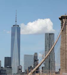
Located in Downtown / Lower Manhattan , this park design by Santiago Calatrava Architects was completed in 2016
NewyorkBeforeID:26062 - 584 pageview


- New York Map
Near Subway station
-
Cortlandt St (Temporarily Closed)
- LINE : 1
-
Interesting building around
OfficesChurchTall BuildingHotelParkNear playground
 11 m RIVER TERR, MURRAY STREET
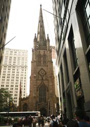
 40.712915 -74.013289 One World Trade Center 20002 104 2014 228 Vesey, West, Washington and Fulton Streets 40.706833333333 -74.01102777777 New York Stock Exchange Building 23276 0 1903 530 Manhattan - New York City 40.708003 -74.012157 Trinity Church 20780 3 1846 371 79 Broadway at Wall Street 40.709938 -74.014421 90 West Street 20613 24 1907 118 90 West Street, 140 Cedar Street 40.710585 -74.015585 One World Financial Center 20118 40 1985 129 200 Liberty Street 40.712459 -74.015354 Two World Financial Center 20066 44 1987 194 225 Liberty Street 40.71 -74.01472222222 West Street Building 23328 0 0 119 90 West St. 40.709942 -74.014147 Club Quarters World Trade Center 21127 19 1931 115 140 Washington Street, 144 Washington Street 40.710974971370504 -74.01414960622787 Liberty Park 26062 1 2016 0 Liberty Street