Adress: 21 East 66th StreetDistrict: Lenox HillBorough: Manhattan, New York City
- Year completed: 1921
- Building Type: Tall Building
Positioning on an old map
Plate 19: Bounded by E. 76th Street, East River (Avenue A), E. 64th Street, and Fifth Avenue. 1885
Positioning on an old map
Central Park And Midtown Farms - Map 1815 1815
Historic map finder tool
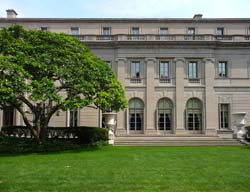
Picture of Chez 66 - NYC
About this place
Located in Lenox Hill , this tall building was completed in 1921
To know more
NewyorkBeforeID:21898 - 608 pageview


- New York Map
-
Interesting building around
ParkMuseumChurchApartment TowerTall BuildingStore40.77319383216072 -73.97249221801758 Central Park 23977 0 1857 651 59th Street / 5th Avenue 40.77126088998363 -73.96713316440582 The Frick Collection 23683 7 1914 353 895 5th Avenue 40.76754351102388 -73.97134959697723 Central Park Zoo 23669 4 0 261 64th Street / 5th Avenue 40.76806161414445 -73.9697952568531 Temple Emanu-El 23703 3 1920 120 1 East 65th Street 40.768037 -73.967871 45 East 66th Street 21860 10 1906 48 45 East 66th Street 40.769262 -73.969032 857 5th Avenue 22613 18 1963 127 857 5th Avenue at East 67th Street, NE Corner 40.767152 -73.968506 Colony House Apartments 22696 0 1959 121 30 East 65th Street at Madison Avenue, SE corner 40.769461 -73.967431 11 East 68th Street 21948 0 1913 159 11 East 68th Street 40.768399 -73.969542 4 East 66th Street 21741 0 1920 99 4 East 66th Street 40.769624 -73.968689 860 5th Avenue 22469 20 1950 157 858-860 5th Avenue at East 68th Street, SE corner 40.768232 -73.968386 Chez 66 21898 0 1921 0 21 East 66th Street 40.769304721405454 -73.96951496601105 107th Infantry Memorial 25299 0 1927 153 West 67th Street / 5th Avenue