New York Map
Interesting building around
Offices

Tall Building

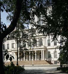
Public Building
Offices
Apartment Tower
Tall Building
Near playground
Federal Office Building [+]
Address
290 Broadway at Reade Street, NE Corner to Duane Street
District: Civic Center
District: Downtown / Lower Manhattan
Borough : Manhatan
Architecture
Year built 1994
Storey 34
Architects Hellmuth, Obata & Kassabaum
Picture
[+]Building type
setKeyword
Near Subway station
-
Brooklyn Bridge - City Hall
- LINE : 4-5-6-6 Express
-
Chambers St
- LINE : A-C
-
Park Pl
- LINE : 2-3
-
Chambers St
- LINE : 1-2-3
-
Chambers St
- LINE : J-Z
-
City Hall
- LINE : N-R
Next, Random
message contain
New York
4316 places - 802 images
copyright 2016-2025 NewYorkBefore.com - Architecture, Heritage & History in NYC - All Right Reserved
copyright 2016-2025 NewYorkBefore.com - Architecture, Heritage & History in NYC - All Right Reserved