What's around   Go | | place | Link
New York Map
40.70413935319792-74.0137231349945 The National Museum of the American Indian23673419073971 Bowling Green40.702171-74.012039One New York Plaza200675019691491 Water Street at Whitehall Street, SE corner40.702297-74.010676Two New York Plaza20223401971195125 Broad Street at South Street, North Corner40.700833333333-74.01194444444Department of Marine and Aviation Piers to South Brooklyn (Municipal Ferry Piers to South Brooklyn)2320001909011 South St40.701265004961236-74.01331289109294Staten Island Ferry2500500125Whitehall Stree

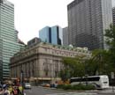
Department of Marine and Aviation Piers to South Brooklyn (Municipal Ferry Piers to South Brooklyn) [+]

Address

11 South St
District: Downtown / Lower Manhattan
Borough : Manhatan

Architecture

Year built 1909
Designated as New York City Landmark - May 25, 1967

Picture

Panorama view (set)
[+]+ floors

Building type

set
Keyword

More about this building

Landmark notice(pdf)

Near Subway station

    South Ferry - LINE : 1
3 m

Next, Random
message contain
 
New York
  • Battery Park City
  • Central Park
  • Chelsea
  • Chinatown
  • Civic Center
  • Downtown / Lower Manhattan
  • East Harlem
  • East Village
  • Financial District
  • Flatiron District
  • Garment District
  • Greenwich Village
  • Hell's Kitchen / Clinton
  • Kips Bay
  • Lenox Hill
  • Lincoln Square
  • Little Italy
  • Lower East Side
  • Meatpacking District
  • Midtown
  • Morningside Heights
  • Murray Hill
  • NoHo
  • SoHo
  • Time Square
  • Tribeca
  • Turtle Bay
  • Two Bridges
  • Upper East Side
  • Upper West Side
  • Washington Height
  • West Village
  • Yorkville

  • 4308 places - 792 images
    © 2016-2024 NewYorkBefore.com - Architecture, Heritage & History in NYC - All Right Reserved